
Mahanadi River System :
Description :
- Mahanadi River covers about 4.3% total geographical area of the country.
- It is bounded on the north by central India hills , on the south and east by Eastern ghats and on the west by the Maikala Range.
- The upper basin is a saucer shaped and mostly lies in chattisgarh state.
- The coastal region of this river is of delta area which is highly fertile.
- 57% of the basin area is cultivable.
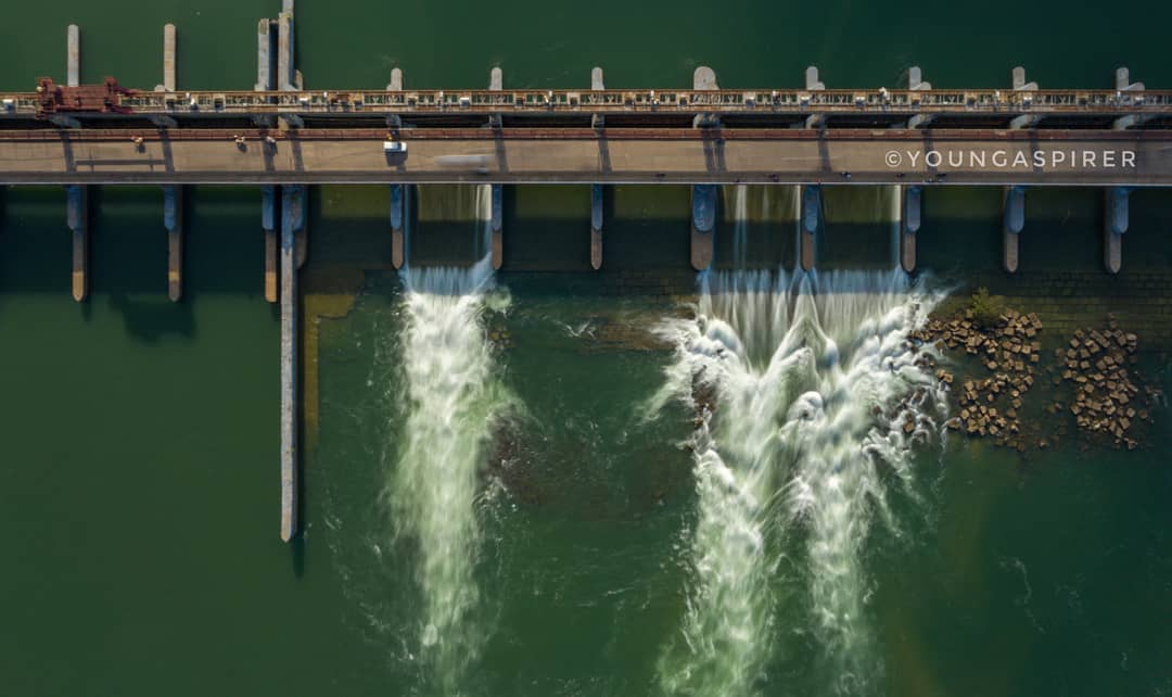
Fig : Mahanadi river flows through Jobra Anicut
Mahanadi River Origin :
- It is one of the East flowing Peninsular river draining into Bay of Bengal.
- The river rises in a pool near to Pharsiya village near Nagri Town in Raipur district of chattisgarh.
- The river lies in the states of Chattisgarh and Odisha.
Tributaries of Mahanadi :
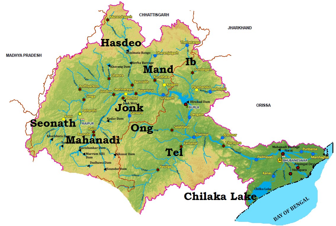
Fig : Mahanadi River basin
Left Tributaries :
- Seonath
- Mand
- Ib
- Hasdeo
Right Tributaries :
- Ong
- Parry
- Jono
- Telen
Tributaries explanation :
- Seonath River :
- It originates from Panabaras Hill in chattisgarh state .
- It joins in Khargahni in Bilaspur district of Chhattisgarh.
- Mand River :
It joins the Mahanadi River in Chandarpur in chattisgarh state 28 km before Mahanadi reached Hirakud Dam.
- Ib river :
- It passes through Raigarh district and Jashpur district of Chhattisgarh state.
- Ib river is famous for its coal belt.
- Major portions of Mahanadi coal belt are situated on the banks of Ib .
- Hasdeo River :
- It is the largest tributary of Mahanadi River .
- Hasdeo Bango Dam is constructed across this river.
- This river originates from Sonhat in Koriya District in chattisgarh.
- The major tributary of Hasdeo river is Gej river.
- Ong River :
- It flows through the state of Odisha.
- It flows through Sambalpur city.
- Jonk River :
- It flows through the state of Odisha and chattisgarh.
- The river originates from Sunabeda plateau and enters in to Maraguda valley.
- Sunabeda plateau is in Odisha state.
- It joins Mahanadi River at Sheorinarayan.
- Telen River :
- It flows through the state of Odisha.
- It flows through Jharsuguda town..
- The historical Kolabira Fort is situated on the banks of this river..
Topography Of Mahanadi River :
- The upper reaches of the sub-basin lies in a very undulating plateau with hill locks eroded moulds.
- The southern part of the plateau is open but to the east and west there are a number of hill ranges, which have steep. slopes resulting in water draining directly into the Mahanadi river.
- The basin upto Manibhadra is continuously sloping towards the main valley and therefore no drainage congestion is anticipated.
Soil types :
- Major soil types found in this rives are Red and yellow soils .
- Laterite soil found in lower parts of Odisha.
- Black soil and sandy soil with Kankar are the main soils found in the part of basin lying in chattisgarh.
Agriculture :
- Paddy is the major crop grown in Mahanadi region.
- Other crops were Wheat,maize ,ragi etc.
Major River projects in Mahanadi River .
- Hirakud Dam
- Ravishankar Sagar
- Dudhawa Reservoir
- Sondur Reservoir
- Hasdeo Bango
- Tandula.
- Korba Thermal power station.
Mineral wealth of Mahanadi Basin :
- The basin is comparatively rich in mineral resources.
- The coal deposits are available in the Ib sub basin in Sambalpur district.
- Coal reserves are also found in Korba, Jatraj, Tamberi, Ronkey, Manikpur and Bisrampur of the Hasdeo sub-basin and in Sundargarh district of Orissa.
- Manganese ore is found in the Jharsuguda district and near Patanagarh of Bolangir district of Orissa.
- Bauxite is found in Kalahandi, Bolangir and Sambalpur districts of Orissa and in Jashpur area of Madhya Pradesh.
- Gold is also found near Dharamjaygarh in the Mand sub-basin and in the Mahasamund area of the Jonk sub-basin. Gold is also available in small quantities on the banks and bed of the Ib river in the Jashpur area.
- Pyrite is available near Katgi.
- Iron ore is found near Dalli Rajara in Rajnandgaon district. Iron ore, Bauxite, Galena are found along the banks of Kurket river, a tributary of Mand.
- Graphite deposits are found in Nuapada, Bolangir, Kalahandi, Sambalpur districts of Orissa.
- Lead, Zinc, Iron Ore, Soap-stone are found in Sundargarh district.
- Limestone, lead, Manganese, Mica, Dolomite, Fireclay, China Clay, Copper, Quartz are also found in the basin.
Hirakud Dam :
- Hirakud Dam is built across the Mahanadi River, about 15 kilometres from Sambalpur in the state of Odisha in India.
- On 15 March 1946, Sir Hawthorne Lewis, the Governor of Odisha, laid the foundation stone of the Hirakud Dam.
- Pandit Jawaharlal Nehru laid the first batch of concrete on 12 April 1948.
- The dam was completed in 1953 and was formally inaugurated by Prime Minister Jawaharlal Nehru on 13 January 1957
- With a great 27 kilometers in length, Hirakud is the longest dam in the world. This dam is of major historical importance, as it was the first multipurpose river valley project undertaken by India post independence.