
OVERVIEW
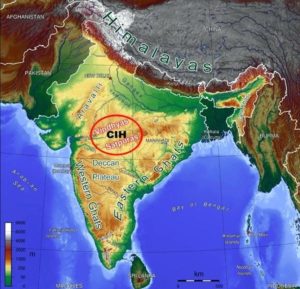
Rising from the height of 150 m above the river plains up to an elevation of 600-900 m is the irregular triangle known as the Peninsular plateau. Delhi ridge in the northwest, (extension of Aravalis), the Rajmahal hills in the east, Gir range in the west and the Cardamom hills in the south constitute the outer extent of the Peninsular plateau. However, an extension of this is also seen in the northeast, in the form of Shillong and Karbi-Anglong plateau.
STRUCTURE
The Peninsular India is made up of a series of patland plateaus such as the Hazaribagh plateau, the Palamu plateau, the Ranchi plateau, the Malwa plateau, the Coimbatore plateau and the Karnataka plateau, etc. This is one of the oldest and the most stable landmass of India. The general elevation of the plateau is from the west to the east, which is also proved by the pattern of the flow of river.
This Peninsular plateau has undergone recurrent phases of upliftment and submergence accompanied by crustal faulting and fractures. (The Bhima fault needs special mention, because of its recurrent seismic activities). These spatial variations have brought in elements of diversity in the relief of the Peninsular plateau. The northwestern part of the plateau has a complex relief of ravines and gorges. The ravines of Chambal, Bhind and Morena are some of the well-known examples.
DIVISIONS
(i) The Deccan Plateau
(ii) The Central Highlands
(iii) The Northeastern Plateau
The Deccan Plateau
This is bordered by the Western Ghats in the west, Eastern Ghats in the east and the Satpura, Maikal range and Mahadeo hills in the north. Western Ghats are locally known by different names such as Sahyadri in Maharashtra, Nilgiri hills in Karnataka and Tamil Nadu and Anaimalai hills and Cardamom hills in Kerala.
Peninsular plateau is located on the Anaimalai hills of the Western Ghats followed by Dodabetta (2,637 m) on the Nilgiri hills. Most of the Peninsular rivers have their origin in the Western Ghats. Eastern Ghats comprising the discontinuous and low hills are highly eroded by the rivers such as the Mahanadi, the Godavari, the Krishna, the Kaveri, etc.
The Central Highlands
They are bounded to the west by the Aravali range. The Satpura range is formed by a series of scarped plateaus on the south, generally at an elevation varying between 600-900 m above the mean sea level. This forms the northernmost boundary of the Deccan plateau.
The general elevation of the Central Highlands ranges between 700-1,000 m above the mean sea level and it slopes towards the north and northeastern directions. Most of the tributaries of the river Yamuna have their origin in the Vindhyan and Kaimur ranges.
The Northeastern Plateau
It is believed that due to the force exerted by the northeastward movement of the Indian plate at the time of the Himalayan origin, a huge fault was created between the Rajmahal hills and the Meghalaya plateau. Later, this depression got filled up by the deposition activity of the numerous rivers.
Today, the Meghalaya and Karbi Anglong plateau stand detached from the main Peninsular Block. The Meghalaya plateau is further sub-divided into three: (i) The Garo Hills; (ii) The Khasi Hills; (iii) The Jaintia Hills, named after the tribal groups inhabiting this region. An extension of this is also seen in the Karbi Anglong hills of Assam.